
6Place Toronto
is a McLuhan Centre for Culture and Technology research/working group project investigating significant urban spaces in Toronto where Media and Infrastructure intersect with Architecture and Public Space. From the Portlands to South Etobicoke, these are contested, iconic, dormant places, currently subject to major speculation and diverse visions for the city of the future. This project investigates urban history, networks, image, building stock, landscape, infrastructure, data and meta-data. Engaging faculty and students in Architecture, Urbanism, Information, Art History, Politics, Anthropology, Media and the Visual Arts, 6PTo’s methods of documentation and dissemination include mapping, lens- and drone-based imaging, drawing, stratography, archival and media research, walks, talks, workshops and seminars. Each of the six investigations is a pilot for an interdisciplinary, layered urbanism and civic broadcast, ultimately testing the potential of Public Space in the North American Metropolis. 6PTo is also supported by U of T’s School of Cities and by the John H. Daniels Faculty of Architecture, Landscape, and Design.
Contents
1/6 Portlands/Monument
2/6 Water/Data
3/6 Work/Inventory
4/6 Creek/Fort/Burial
5/6 Islands/Bubbles
6/6 Landfill/Publics
About | Land Acknowledgement | Credits |
︎


Home
Work/Inventory
“A
look at a patch or field of 1960’s small scale industrial buildings in west
Toronto in which the uses they accommodate are undergoing a second or
even third wave of reinvention.”
![]()
![]()
Work and workplaces are changing. Some of these changes are being studied in search of new policy, planning and design directions. Others are just happening.
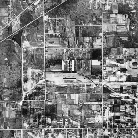
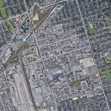
Our discussions and walk will focus on an area where the latter is the case - an area of South Etobicoke roughly bounded by: Islington Avenue on the east; Jutland Avenue to the south; Kipling Avenue to the west; and the Canadian Pacific Galt Subdivision rail corridor to the north.
This area is an “employment area” in official terms – developed originally as an incremental conversion of agricultural lands starting in the in the mid 1950s – mostly small scaled single storey buildings on served by an arterial road system laid out along with the expressway network in the early 1960’s.
At the area’s north west corner is the “6 points” intersection- a complex intersection conceived at the time as a “fly over” or “cloverleaf” which is no undergoing a “reurbanization” to create an at grade intersection and a new “civic centre”. Just to the west of this intersection in the western terminus of the TTC’s Line 1 Bloor Danforth subway line. To the west are a collection of large scale industrial heavier industrial building sites that are in a process of conversion to new uses some for film studios. To the east and south the area abuts contemporaneous low scale residential neighbourhoods.
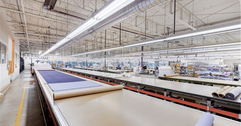
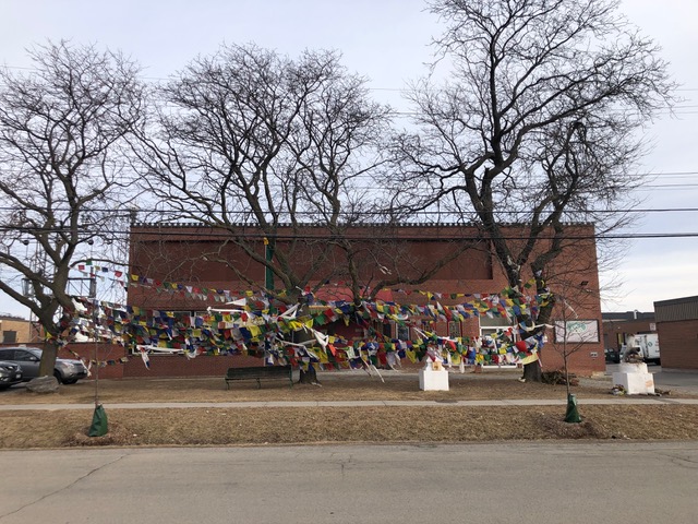
The area itself is evolving from its original light industrial and manufacturing uses to a more complex mix of automotive, food, office, making and working activities – more or less unexamined by official planning efforts – while for the most part maintaining the form of the first generation of building.
The area is characterized by the presence of a small scale, almost residential scale street grid with buildings set back from the streets with a mixture of parking and landscaping. Paved parking, loading and maneuvering spaces make up the majority of the non-street-facing surfaces of the area. Many of these flow together across individual property lines creating a more or less continuous asphalt field.
Our walk amongst the workplaces will be the first steps in an examination of the evolution of this area and an exploration of the rich potentials that such areas represent for the future of the City and for work.
Work and workplaces are changing. Some of these changes are being studied in search of new policy, planning and design directions. Others are just happening.
Our discussions and walk will focus on an area where the latter is the case - an area of South Etobicoke roughly bounded by: Islington Avenue on the east; Jutland Avenue to the south; Kipling Avenue to the west; and the Canadian Pacific Galt Subdivision rail corridor to the north.
This area is an “employment area” in official terms – developed originally as an incremental conversion of agricultural lands starting in the in the mid 1950s – mostly small scaled single storey buildings on served by an arterial road system laid out along with the expressway network in the early 1960’s.
At the area’s north west corner is the “6 points” intersection- a complex intersection conceived at the time as a “fly over” or “cloverleaf” which is no undergoing a “reurbanization” to create an at grade intersection and a new “civic centre”. Just to the west of this intersection in the western terminus of the TTC’s Line 1 Bloor Danforth subway line. To the west are a collection of large scale industrial heavier industrial building sites that are in a process of conversion to new uses some for film studios. To the east and south the area abuts contemporaneous low scale residential neighbourhoods.
The area itself is evolving from its original light industrial and manufacturing uses to a more complex mix of automotive, food, office, making and working activities – more or less unexamined by official planning efforts – while for the most part maintaining the form of the first generation of building.
The area is characterized by the presence of a small scale, almost residential scale street grid with buildings set back from the streets with a mixture of parking and landscaping. Paved parking, loading and maneuvering spaces make up the majority of the non-street-facing surfaces of the area. Many of these flow together across individual property lines creating a more or less continuous asphalt field.
Our walk amongst the workplaces will be the first steps in an examination of the evolution of this area and an exploration of the rich potentials that such areas represent for the future of the City and for work.
Host/Curator:
Mark Sterling
Mark Sterling
Talk
by
Jesse LeCavalier
Associate Professor, the John H. Daniels Faculty of Architecture, Landscape and Design
and
Shawn Micallef
Writer, Toronto
A Walk
Amongst the Workplaces
A conversation between Shawn Micallef and Jesse LeCavalier on life and change in employment areas – moderated by Mark Sterling.
at The John H. Daniels Faculty of Architecture, Landscape, and Design
1 Spadina Crescent, Toronto
Room 200 (Mediatheque)
Fri, Mar 29/19
6:30pm - 8pm
6:30pm - 8pm
Walk
in Toronto’s South Etobicoke.
A walk with Shawn and Jesse through an evolving employment area in South Etobicoke and a discussion on-site – moderated by Mark Sterling.
![]()
Itinerary
The Etobicoke visit will start at the South Lot entrance to Kipling Station on TTC Subway Line 2 at 10 AM Saturday 30 March 2019. Please try to be there by 9:50 AM so that we can organize the transport.
The visit will include walking and car/small bus transport between several locations in the light industrial area generally to the south and east of Kipling Station. There will be visits to at least two of the evolving uses which the existing industrial buildings in the area accommodate – a community centre and a cooperative work space.
At the end of the itinerary the group will assemble for a brief discussion of the visit and next steps for ongoing research on the area. Transport back to Kipling Station is included in the visit.
The Route for the visit can be found at: https://www.google.com/maps/d/viewer?mid=15jJosdgsGGQgmYzWEuz_ts1D1WPT46SH&usp=sharing
in Toronto’s South Etobicoke.
A walk with Shawn and Jesse through an evolving employment area in South Etobicoke and a discussion on-site – moderated by Mark Sterling.
Itinerary
The Etobicoke visit will start at the South Lot entrance to Kipling Station on TTC Subway Line 2 at 10 AM Saturday 30 March 2019. Please try to be there by 9:50 AM so that we can organize the transport.
The visit will include walking and car/small bus transport between several locations in the light industrial area generally to the south and east of Kipling Station. There will be visits to at least two of the evolving uses which the existing industrial buildings in the area accommodate – a community centre and a cooperative work space.
At the end of the itinerary the group will assemble for a brief discussion of the visit and next steps for ongoing research on the area. Transport back to Kipling Station is included in the visit.
The Route for the visit can be found at: https://www.google.com/maps/d/viewer?mid=15jJosdgsGGQgmYzWEuz_ts1D1WPT46SH&usp=sharing
Sat, Mar 30/19
10am - 2pm
10am - 2pm