
6Place Toronto
is a McLuhan Centre for Culture and Technology research/working group project investigating significant urban spaces in Toronto where Media and Infrastructure intersect with Architecture and Public Space. From the Portlands to South Etobicoke, these are contested, iconic, dormant places, currently subject to major speculation and diverse visions for the city of the future. This project investigates urban history, networks, image, building stock, landscape, infrastructure, data and meta-data. Engaging faculty and students in Architecture, Urbanism, Information, Art History, Politics, Anthropology, Media and the Visual Arts, 6PTo’s methods of documentation and dissemination include mapping, lens- and drone-based imaging, drawing, stratography, archival and media research, walks, talks, workshops and seminars. Each of the six investigations is a pilot for an interdisciplinary, layered urbanism and civic broadcast, ultimately testing the potential of Public Space in the North American Metropolis. 6PTo is also supported by U of T’s School of Cities and by the John H. Daniels Faculty of Architecture, Landscape, and Design.
Contents
1/6 Portlands/Monument
2/6 Water/Data
3/6 Work/Inventory
4/6 Creek/Fort/Burial
5/6 Islands/Bubbles
6/6 Landfill/Publics
About | Land Acknowledgement | Credits |
︎


Home
Portlands/Monument
The Port Lands occupy a 1,000-acre, 100-year
old shipping and industrial landfill over the former Don River delta and
marshlands, to the Southeast of old Toronto. Formed throughout the 20th
Century in different periods of industrial and infrastructural development, these
engineered lands frame Toronto’s Inner and Outer Harbours, a significant, part-accessible
length of the Metropolitan coastline and an artificial headland extending into
the Toronto Islands. They are publicly-owned and –regulated, subject to major
speculation, investment and redevelopment plans.
The Port Lands form a block as wide as Manhattan and as long as the Champs Elysées, roughly the same size as central Venice. Formed and reformed by changing frameworks of land-management and –ownership, they are a patchwork and aggregate of post-urban structures, landscapes and ecologies: industrial buildings and channels, post-industrial remains, reclaimed wetlands, beaches and public spaces, fenced port, shipping, logistics and studio lots, roads, railway lines, paths and bridges, and multiple contaminated strata of land, water and sediment, held in place by the gridiron plan and at least half a million cubic metres of concrete. Their networks are transport lines and zones spaced at an infrastructural scale; and major waste, water and power lines running at a regional scale. These networks are punctuated by a series of nodes: industrial landmarks built at a monumental scale.
The landmarks of the Port Lands are fragmented and inaccessible. They give, due to the flat landfill and their seclusion, few vantage points toward each other or toward Downtown Toronto. They are hard to visualize or imagine as situated urban objects, and yet they are very much there: iconic, broadcast into the public consciousness as tremendous buildings and cavernous interiors via a series of films, stories and festivals. They are post-urban, mediated, infrastructural behemoths halfway between decommission and catastrophe, monuments for the screen but not (yet) for the city.
The Hearn Generating Power Station is the Port Lands’ major landmark. Its scale, contamination and state of disrepair –like many Crises that lead to expropriations of the Commons– played a role in its recent change of ownership. Sold by a public utility company to a film studio, inaccessible due to liability, the Hearn is as wide as the Great Pyramid of Giza, as long as St. Peter’s Square and as massive as the Acropolis Hill.
The Port Lands are a landform blocking flows and erasing histories, a coastline rebuilt over layers of sedimented pollution and turned into infrastructure. The Hearn is a dislocated icon, an island on the island. The building broadcasts scenes and stories of the infrastructural and virtual sublime against the optimized future city visions, the fluid zones and indeterminate coastal landscapes of Lake Ontario. Both are gates (or launch pads) to a new urban Archipelago of the Great Lakes.
Host/Curator:
Petros Babasikas
Petros Babasikas
Talk
by Nicolas de Monchaux
Professor of Architecture and Urban Design, Director of the Berkeley Center for New Media, UC Berkeley
Rebel Plans: Apple, Star Wars, and Architecture at Bay.
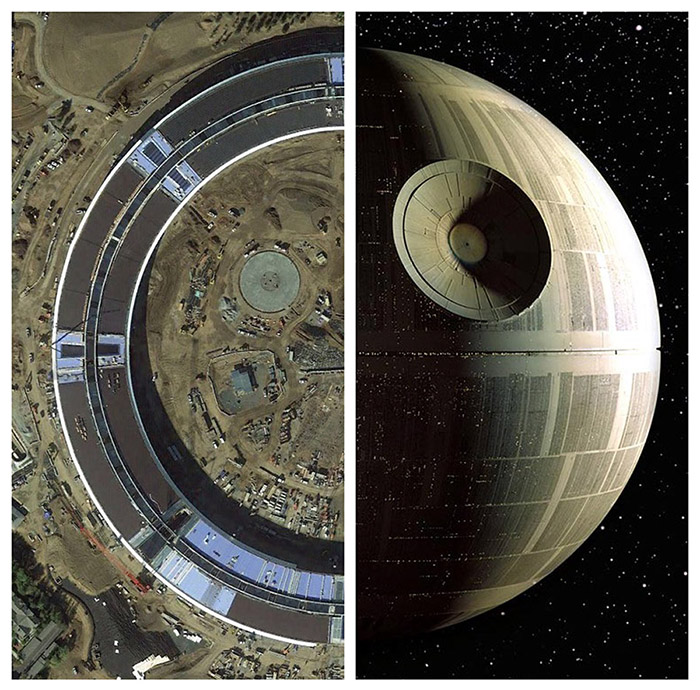
The San Francisco Bay Area, home to only seven million of the United States’ 325 million inhabitants, is generally consigned to the footnotes of architectural history. But if one takes only a slightly broader definition of ‘architecture’ — one that acknowledges the many ways in which design and technology have profoundly transformed our landscapes and cities in the last few decades — a different view emerges. Central in this expanded field are two cultural monoliths at architecture’s periphery — Apple Computer, as embodied in its enormous new headquarters, and George Lucas’ imagined universe of Star Wars, embodied in the massive architecture of the Death Star. The two structures, it turns out, share an essential history not only with each other, but also the professional disciplines of architecture and city planning. Engaging this history and its prospects for design today, we can gain a new insight on the ethics, outcomes, and outlines of an emerging, technologically mediated interaction with space and city happening worldwide.
at The John H. Daniels Faculty of Architecture, Landscape and Design
1 Spadina Crescent, Toronto
Room 200 (Mediatheque)
Fri, Nov 30/18 5pm- 6:30pm
Workshop
at The John H. Daniels Faculty of Architecture, Landscape and Design
1 Spadina Crescent, Toronto
Room 230
with: Petros Babasikas, Roberto Damiani, Nicholas de Monchaux, Justine Holzman, Heba Mostafa, Ala Roushan, Charles Stankievech, Mark Sterling.
Sun, Dec 2/18
1pm - 3pm
1pm - 3pm
Walk
at Toronto’s Port Lands
What are the –present and possible– public spaces of the Port Lands? How do these public spaces relate to the industrial landmarks and to the commons, networks and dynamic landscapes of water? How do plans and infrastructures of processing/optimization measure against these landscapes of indeterminacy and resilience? What are the local erasures and memory losses required for the growth of monuments? What is the history of landfill and is it possible for a new city to be built on it from scratch? Can film production generate a new urban architecture? Is drawing the first act of reconnaissance, a blueprint for breaking into the inaccessible buildings, for visualizing the invisible? What media document the scale of the terraform, the region, the infrastructure and the walk?
Jun 2019
More info soon
More info soon